
The Best El Chaltén Hikes: One Week Hiking in El Chaltén, Patagonia
I first visited Argentinian Patagonia in the Autumn (April) of 2018 and miraculously had the most non-Patagonian experience. With little to no wind and beautiful clear skies for nearly two weeks we were able to explore town, go on day hikes in El Chaltén, visit lookouts, take a boat ride around Puerto Merino Glacier and even sneak in a small two night backpacking trip.
Thankfully, my luck did not run out this time and Mike and I were able to hit another perfect weather window (I am starting to think that I might be good luck for Patagonia weather). With only 6 days to spend in town we arrived to rain and the promise of one week with perfect weather.
It arrived the following day around noon and we were able to spend our five days in El Chalten hiking over 100km including four day hikes and one overnight mountaineering trip. This El Chalten hiking guide is everything you need to know about el Chalten hikes, trail information, packing tips and more.


El Chalten sign

Valley near El Chaltén
How to get to El Chaltén
The easiest way to get to El Chaltén is via a 3h15 direct daily flight from Buenos Aires to the town of El Calafate, Argentina. Who I visited in 2018 I had private transportation - and this year I opt’ed for public transportation and flew into El Calafate and took the bus to El Chaltén.
It was super easy to navigate and very straightforward from the airport. And if you want to try hitchhiking, is not only very safe in Patagonia but also a very common practise as popular destinations are not always very near to one another.
For example, the town of El Calafate (where you would fly into) is 213km (a 3h15 drive) from El Chaltén. But if while you are in Argentinian Patagonia you wanted to see the Puerto Merino Glacier (highly recommend) it is a 90 minute drive (96km) from town.
If you are renting a car, note that the petrol station in El Chaltén is cash only (Argentinian pesos) and oftentimes the ATMs are out of cash (especially on Sundays) so before leaving El Calafate strongly consider stocking up on cash.
If you found all of that at least a little confusing... welcome to Patagonia!

Flight path from Buenos Aires to El Calafate

When is the best time to visit El Chaltén
The average annual maximum temperature in El Chaltén, Argentina is 12°C (54°F) and the average annual minimum temperature is 2°C (36°F). Since it is not right on the ocean the temperatures fluctuate a little bit more than other parts of Patagonia.
The hottest month of the year is January and the coldest month is typically July. The weather can be unpredictable as with any mountainous region. Be ready for everything always but I put a little breakdown below. I have visited between early February and late April and each time had sun, rain, wind and snow!

Average temperatures in Lago Argentino
December – February: This is the high season (summer months) in El Chaltén, the warmer temperatures bring travellers from all over the world for hiking El Chaltén trails. Peak season means that this is the time to book your trip in advance as this is a tiny town with limited options of accommodations. Temperatures usually hover between 15-25°C (60s-70sF), with nightly lows around 7°C (mid-40s). Summer offers less precipitation but strong winds, with gusts reaching up to 120km/h (75mph) in town.
March – April: The end of February is when locals go back to school - marking the end of summer and the beginning of autumn. Days are getting shorter, temperatures a bit colder, and precipitation more likely. You will find less busy trails and calmer winds - peak fall colours tend to be in mid March but you can also get snow any time during this period.
September – November: Depending on the winter snowfall - during this time you may still have snow on the ground (and it will definitely still be in the high alpine). But this is a great time to come with fewer crowds on low snowpack years.

La Roti
What to eat in El Chaltén
Empanadas - the best empanadas in town can be found at El Parador Comida Para Llevar (the chicken empanada is chefs kiss) with second place going to La Roti (try the guanaco). Note that El Parador is only open for dinner (after 7pm) so if you would like a daytime empanada - La Roti will be your best bet.
Alfajore - closed on Tuesdays, La Chocolateria Josh Aike make the best alfajore in town. These are a wonderful sweet treat and a great gift to bring back with you.
Coffee - we had a post-hike ritual of going to PAISA High Mountain Coffee (a flat white for me, an americano for Mike). I would confidently say that this is the best coffee in town - but would go elsewhere for snacks and treats.
Sandwiches - if you are in the mood for a sandwich - La Lomiteria El Chalten - is your go to.
Pasta - Maffia has fresh, in-house made, pasta and an extensive wine list. I would recommend making a reservation (we showed up without one and were seated at a communal table which was great for us but… if thats not your jam, they do take reservations).
Pizza - try Laborum if you are in the mood for pizza in El Chaltén. We also tried Patagonicus and it had better hours of operation on a North American schedule and would eat there in a pinch but would pick Laborum every time.
Splurge Meal - we went to Parrilla La Oveja Negra on our first night in El Chaltén and it was (by a comfortable margin) the most expensive meal. We ordered the lamb, rib eye, french fries (Mike), and roasted vegetables and each had a sparkling water and it ended up being about $50USD.
However, both the quality and volume of food in north America would easily be triple the cost and I would absolutely recommend going here for your sludge meal in El Chaltén.

Short El Chaltén hikes, viewpoints and backpacking trips

Cerro Torre
1. Mirador Cascada Margarita
Distance: under 2km roundtrip (about one mile)
Elevation: 80m (250ft) gain
Duration: 1 hour
Difficulty: Easy
Trailhead: marked trailhead on Calle Riquelme (follow Avenida José Antonia Rojo up the black metal staircase and turn left)
This short hike is the first stop on the longer Laguna Torre hike and a great first view of Cerro Torre. If you are really pressed for time or just want to stretch your legs with an amazing view this is a great stop!

Mirador Cascada Margarita
2. Mirador Cerro Torre
Distance: 7km roundtrip (4.3 miles)
Elevation: 200m (650ft) gain
Duration: 2 hours
Difficulty: Easy
Trailhead: marked trailhead on Calle Riquelme (follow Avenida José Antonia Rojo up the black metal staircase and turn left)
Continuing on the trail from Mirador Cascada Margarita - this viewpoint is well marked with benches and even a pit toilet (although I would only recommend using it if you are in an extreme emergency). It has a beautiful view of the Cerro Torre Range and makes a great snack stop along your way to Laguna Torre. This is ideal for families, new hikers, or for those simply wanting to catch the sunrise without waking up too early for an El Chalten treks!

Mirador Cerro Torre
3. Mirador Los Cóndores
Distance: 3-5km round trip (2 to 3 miles)
Elevation: 90m (300ft) gain
Duration: 2 hours
Difficulty: Easy
Trailhead: Los Glaciares National Park ranger station
This hike is an ideal first day sunrise hike. it offers beautiful views of the Fitz Roy Range. Follow the path that leaves from the ranger station, taking a left at the junction less than a quarter mile from the trailhead.
Here, the short trail rises steeply above town, offering stunning, 360-degree views of the Adela, Fitz Roy, and Torre massifs, and the Río de las Vueltas valley. Stop at Mirador Los Cóndores or if you are feeling up to it, continue along the rail for less than a mobile to Mirador Las Águilas for views of Lago Viedma in the opposite direction.

Mirador Los Cóndores
4. Laguna Capri
Distance: 8km round trip (5 miles)
Elevation: 215m (700ft) gain
Duration: 4 hours
Difficulty: Moderate
Trailhead: Parking lot at north end of Avenida San Martín
Leaving from the trailhead at the north end of town, ascend a steep slope to arrive in an open valley with views of the Fitz Roy Massif. Here, the trail weaves through a forest of ñire and lenga trees, arriving at Laguna Capri in less than two hours.
Multiple beaches provide opportunities for lounging with a view of the Fitz Roy Massif on the horizon. This is the nearest campground to El Chaltén and offers pit toilets.

Laguna Capri
6. Cañadon Rio De Las Vueltas
More of a viewpoint than a hike, this classic view of the Fitz Roy Range requires a vehicle (if you dont have one, nobody really does, hire a taxi for a few dollars) and watch the sunrise from either the road or a (very) short walk to the river overlook. This is 6km (about a 6 minute) taxi ride from the town of El Chalten.

Cañadon Rio De Las Vueltas
El Chaltén Full Day Hikes

Laguna Capri
1. Laguna Torre
Distance: 20km (12.5 miles) round trip
Elevation: 515m (1,700ft) gain
Duration: 6 hours
Difficulty: Moderate
Trailhead: Marked trailhead as Calle Riquelme (follow Avenida José Antonia Rojo up the black metal staircase and turn left)
One of the most popular day hikes in El Chaltén, the trail to Laguna Torre meanders alongside Río Fitz Roy, offering incredible, all-day views of the Torre Massif - it’s one of the best hikes in El Chalten for a reason! This is the perfect pairing to Laguna de los Tres hike, allowing you to capture views of the adjacent river valley and granite spires that so often remain hidden behind the towering Cerro Fitz Roy.
Leave from the trailhead on the hill above town, ascending steeply at first and then navigating gently up and down on a well-worn trail. Enjoy your first view of the Torre Valley after just an hour of hiking, then continue down through lenga forests and beside the raging Río Fitz Roy.
The trail remains rather flat throughout this section, until the last mile brings you up to Campo de Agostini and the shores of Laguna Torre. Here you’ll find up-close views of the Torre Massif, icebergs floating in the glacial lake, and perhaps even climbers crossing a Tyrolean traverse on the way to the Torre Valley.

Laguna Capri
2. Laguna De Los Tres
Distance: 21km (13 miles) round trip
Elevation: 940m (3,100ft) gain
Duration: 8 hours
Difficulty: Difficult
Trailhead: Parking lot at north end of Avenida San Martín
It’s a tough choice, but if you only have one day to hike in El Chaltén, Laguna de los Tres probably should be at the top of your list. Be sure to choose a day with clear skies and low winds, however, as this trail ascends a high and exposed slope to the base of Cerro Fitz Roy (and it’s best to start early).
Leave from the trailhead at the north end of Avenida San Martín, ascending quickly into a forest with views of Río de los Vueltas to your right (the same trail as for Laguna Capri). After about two miles, a sign will show two options—head left to hike beside Laguna Capri, or right to ascend a hiking trail for Mirador Fitz Roy. Both options are similar distances and converge in a few more miles, just before Campo Poincenot.
Continue through both Campo Poincenot and Campo Río Blanco to the base of a scree slope. Here begins the crux of the hike: ascend this very steep and challenging hillside for over 1,200 feet to Laguna de los Tres. Once at the lake, take a deep breath, put on some layers, and enjoy up close views of Fitz Roy, Glaciar de los Tres, and the stunningly blue waters. You can walk along the lakeshore or head to the left about half a mile for spectacular panoramic views over Lago Sucia in the adjacent valley.

Laguna de los Tres
El Chaltén Multi-day hikes and Overnight circuits

EL Chalten Circuit
1. El Chalten Circuit (turning Laguna Los Tres and Laguna Torres from day hikes into one two-night backpacking trip)
Distance: 34km+ (21 miles)
Elevation: 1,250m (4,000ft) of total gain & loss
Difficulty: Easy
Trailhead: Parking lot at north end of Avenida San Martín
Duration: Three Days (2 nights)
Day one: Hike to Poincenot campground. We left after lunch and had plenty of time not only to make it to the campground but also to scout out Laguna de Los Tres for sunset (the clouds can roll in quickly and unexpectedly and I wanted to ensure I was able to see Fitz Roy) I recommend this even if it does mean doing double the steep scree section.
Day two: Back up to watch the sunrise at Laguna de Los Tres (this is a 2km hike with 350 of elevation gain - the hiking trail is well maintained and very popular.... but it is steep), pack up camp hike to Agostini campground.
Day three: Our final morning we had sunrise at Cerro Torre and then back to El Chaltén in time for dinner in town. One of the nice things about this hike is that it both begins and ends in about the same place (2 blocks away) and within a 5-minute hike of the centre of town.
Note: For the Fitz Roy & Cerro Torre Circuit you do not need to reserve campsites (at the time of writing this) as everything is first come first serve and at the time of writing this there was no fee (including park entrance) for this area. Please be respectful so that it is kept this way. When we were there we found two men camping right along the shoreline of Laguna de Los Tres which is extremely illegal. Practise LNT principles.
2. Huemul Circuit
Distance: 65km+ (40+ miles)
Elevation: ~4,900m (16,000ft) of total gain & loss
Difficulty: Difficult
Trailhead: Parque de los Glaciares ranger station
The Huemul Circuit is a four-day, challenging hike that has it all: meadows and forests, rivers and Tyrolean traverses, rocky moraines, iceberg-laden bays, and windy passes. But the unmistakable highlight of the circuit is the unparalleled views of the Southern Patagonian Ice Field, the largest non-polar ice mass in the world.
This hike is a serious undertaking and only to be attempted by experienced backpackers. You’ll need to register with the visitors’ center (you can do so online here), compile all the required gear for the Tyrolean traverses, and make sure that the weather is suitable for ascending high and exposed mountain passes.
Mountaineering

Mountaineering in El Chaltén
Before reading further, if mountaineering is something that you are interested in, I strongly recommend taking an introduction safety course. I have a whole blog on my experience on the Beginners Mountaineering Course that you can check out via the button below. Mike and I also opted to hire an IFMGA certified guide for our mountaineering objective in El Chaltén.
As we are unfamiliar with the mountain and the stakes are so high when rock climbing and glaciers are involved I would always recommend this in any unfamiliar territory. Especially when just starting out.
With that being said - these are four more entry level mountaineering objectives in El Chaltén that Mike and I considered hiring a guide for. We ended up settling on Mojón Rojo.
1. Cerro Madsen
Distance: 25.4 km
Elevation: 1,102 m
Technical Aspects: This will require crampons, a harness, ropes and basic mountaineering experience.
Duration: One Day (12-14h)
Start hiking early in the morning or perhaps late the evening before for an alpine start. You can either start hiking from town (distance mentioned above) or take a small transfer north of town to save about an hour of hiking.
Make your way to Poincenot campsite to Laguna de los Tres (Fitz Roy Look-out). To the right, Cerro Madsen. Depending on the snowpack and time of year, technical gear and third class climbing will be required. The summit offers some of the best views of Fitz Roy.
2. Cerro Electrico
Elevation Gain: 1,700.
Technical Aspects: This will require crampons, a harness, ropes and basic mountaineering experience. Comfort on slopes of at least 35°
Duration: One Day (12h)
Rising in the south of Argentina is the Cerro Eléctrico that measures 2,257 meters.
Its name comes from the fierce noise that is created by the wind in the valley, which resembles the strikes of thunder.
Beginning in the mountain village of El Chaltén, which is located in the gorgeous Glaciares National Park, we’ll take an early morning drive to Río Eléctrico, which is about 10 miles away.
From the Río Eléctrico, we will begin hiking on the trails to Piedra del Fraile, a comfortable and easy trail which provides access to the Valle del Río Eléctrico.
After 30 minutes we’ll head off the trail and turn towards a dry canyon that presents steep slopes. This route brings us to the base of the glacier.
It is from here that we need to use crampons and rope to help us climb the very steep section.
Upon a successful climb you’ll gain access to breathtaking views of the Rio Fitz Roy mountain and Piedras Blancas Glacier.
3. Mojón Rojo
Elevation Gain : 1,700m
Technical Aspects : This will require crampons, a harness, ropes and basic mountaineering experience. Comfort on slopes of at least 35° (there are more technical routes and our guided ended up taking us on a route with up to 60° slopes and some technical climbing)
Duration : Two Days (one night)
Day one: Meet your guide, hike either from town or north of town to save an hour of hiking (we did this). Hike past Poincenot camp, about 2 ½ hours and continue to the shoreline of Laguna Sucia. One of the most spectacular places in the park. From la Laguna, we went up 700 more meter up to “La Cueva” the cave, our camp for the night. The views of Glacier Sucio is incredible.
Day two : You will wake up early for an alpine start, have breakfast and kick off the day. This will help take advantage of the over night freeze. We scramble through a short section of rock up to the glacier’s toe. Where you rope up and we keep moving up towards the feeding zone of the glacier.
The early sun hitting the granite needles with its first light with all this white glacier background is just amazing. The last bit of a climb is a 3rd/4thclass on the French scale. There are also options for more technical routes, we went up a small colour with a 60° incline and from 5.9 climbing. You will follow the ridgeline up to the summit (and don’t forget to climb to the true top of Mojon Rojo!). Take some photos, head back to camp, have lunch, pack up and head back town to town.

Mojón Rojo
4. Cerro Solo
Technical Aspects: 40-45° snow/ice slope, mountaineering experience is recommended
Duration: Two Days (one night)
Day one : Meet your 7:00 in the morning. Gear, food checking and arrange last minute details. Atart hiking for 2 ½ hours through Beech forest, where if you are lucky you could spot a Magellan woodpecker. You will reach Laguna Torre and its lateral and terminal moraines that glacier Grande left.
You cross Fitz Roy river using a Tyrolean (a zip line with a pulley) and our harnesses. Keep hiking along the southern lateral moraine until reaching Cerro Solo Buttress. 150 meters up and Cerro Solo stream shows up. Following the creek up to its basin, we ascent 900 meters.
Some sections of rock where you may use your hands to progress. Finally, reach the base of the lower glacier. Set up camp, have dinner and an early night.
Day two: Early in the morning wake up. Wanting to take advantage of the over night freeze. Put crampons and harness on immediately to progress on a 30 35-degree snow/ice slope. Depending on snow/glacier condition you might be walking on ice, snow or rock.
After a couple of hours, you will reach the bottle neck (joint between the Upper glacier with Lower glacier). Cross the bergshrung where possible and a short section of 40/45 degrees leave us in the upper glacier. Aprox 1 hour more until the summit.
Views are just amazing! Continental Ice Cap, Cerro Torre Range, Fitz Roy Range, Adelas, Pier Giorgio among others. After clicking your cameras and mind, time to start your way down to town.
Where to stay in el Chaltén
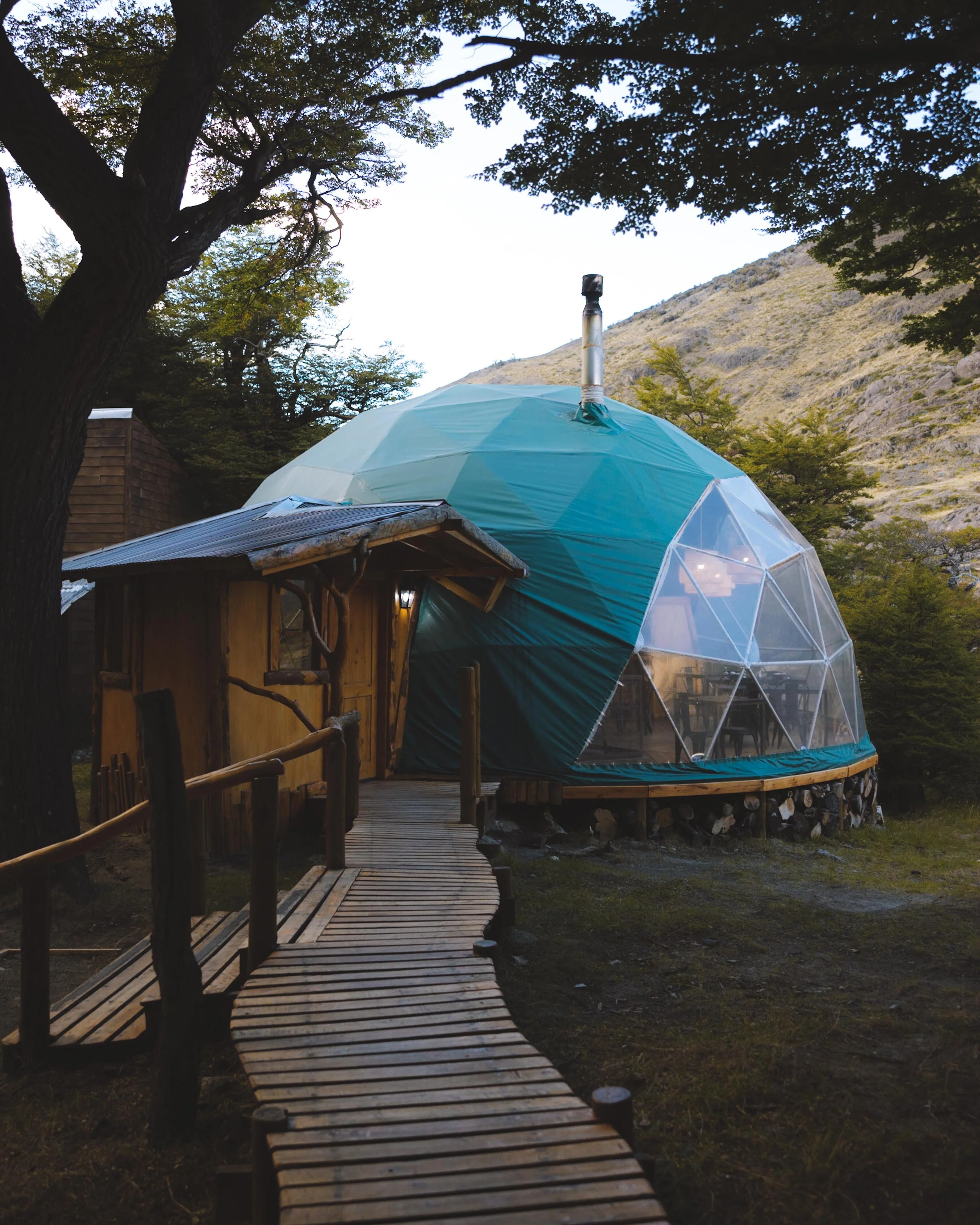
Patagonia Eco Domes
I will not add in a comprehensive list here. Most people in El Chaltén seem to stay at hotels or rent private apartments. The later is what I have done on both of my trips to the region. However, if you are looking for a unique stay I would recommend looking into the Patagonia Eco Domes.
A number of the hikes above mention the start point at a trailhead north of town (it is on the way to the Humuel Circuit trailhead and also cuts off an hour for the Laguna Los Tres hike). It is about a 30 minute taxi ride (again extremely inexpensive taxi rides in Argentina) from the town of El Chaltén. It was a super unique stay and the food was incredible.
What to pack for El Chaltén
As one of my most asked questions always I I have included all of the information on what I packed for the entirety of my one week trip to El Chaltén as well as my one night ascent up Monón Rojo. You can find those by clicking the images below.


*Please note that some of the links above are affiliate links, and I may earn a small commission on any purchase made - at no additional cost to you. As always, all ideas and opinions expressed in this post are entirely my own. Thank you for your support!
Like this post? Pin it for later and share it with others!


