
The Ultimate Fourteen Day Yukon Road-trip
This blog is written in partnership with and was supported and organized by Yukon Wild.

Visiting the Yukon has been, for years, a bucket list trip for me. Driven not only by my love for glaciers and bears but by my personal goal to visit every Canadian Province and Territory (ideally before 30, but we all know I am too late for that). The Yukon was the final part on that list I and was elated when Yukon Wild reached out to me and invited me to explore the Territory. My trip was fifteen days in total - the first and last being travel days - and it was nothing like I imagined it would be; even after visiting both of Canada’s other northern territories. The landscape is vast, the mountains are tall and yet, somehow its capital city is located in a near desert climate.
the basics:
Best time to visit
We asked this question everywhere we went. And the answers varied. If you are skiing Mount Logan - the season is early - mountaineering in the Icefield Ranges is permitted from March 15 to Nov. 15 and the climbing season extends from mid-April to mid-June. When our flight to the ice field was cancelled for the third time we were informed that in August it is quite typical as the weather begins to deteriorate and that the best flying time is June and July. However when backpacking we were told that is also when the bugs are the worst. We only saw bugs (mosquitos) and not very many, during our backpacking trip into the Coast Mountains. Typically by August they are gone. However August and into September brings a lot more rain. But with that comes some of the most beautiful fall colours that peak anywhere from mid August to mid September (and with the nights getting longer and darker there is a higher chance of seeing the Northern Lights).
So the answer to this is dependant on what you want to do. I think, for myself, ideally mid July or early September would be the best time to visit the Yukon.

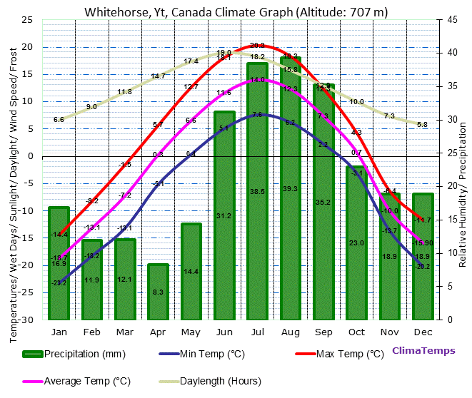
Climate
These maps are for Whitehorse but give a good general idea of what the temperatures, precipitation and hours of sunlight are in the Yukon. The further north you go (Whitehorse is quite south in the territory) the more extreme these differences between summer and winter will be.

How to get there
We flew from Calgary with Air North. It has one re-fuel stop in Edmonton but the total trip time was under five hours for us. We did need to provide proof of COVID vaccination submitted to the health minister or would need a two week quarantine to enter the Yukon. There was also a small health questionnaire we filled out upon arrival. A lot of people from British Columbia (and a few from Alberta) planned long road trips to make their way to the Yukon. As well, with the Canada-US border opening there is an opportunity to have the Yukon as part of your journey from the lower 48 up to Alaska.
My route
Itinerary:
Day one
Arrive in Whitehorse - we flew with Air North. They offer two free checked bags which is necessary for anyone who is going to be doing any hiking/backpacking as backpacking backpacks typically are too large to be classified as carry on items. As a surprise bonus we were given a full meal and warm cookies on our flight up; no other airline offers these on flights from Calgary-Whitehorse.
Get settled in Whitehorse
Where to eat
Wayfarer - Oyster Bar
Miner’s Daughter/The Dirty Northern Bar - Best Pizza in Town
Klondike Rib & Salmon - get the fish dishes. The Salmon and Arctic char are both amazing (they were out of Halibut) but the ribs and pasta dishes we tried were pretty average. Good, but average. Go with the fish.
Kind Cafe - Great coffee and smoothies. A lot of vegan/GF options
Baked Cafe
The Winter Long Brewery
Where to sleep
The Best Western - honestly. It is reliable and predictable and (for Whitehorse) reasonably priced. And they have a laundromat downstairs if you come back from backpacking and need some clean clothing (but be warned it is two loonies and three quarters for each of the washer and dryer which is an odd amount of change). The room was large enough to hang all of our wet clothes, gear and tent after backpacking.
other useful information
Coast Mountain Sports is essentially an REI/MEC in Whitehorse. It has all of your camping/backpacking/outdoor gear needs.
Tahikini Hot springs (it was closed while we were in town but apparently is really nice)


Days Two-seven
backpacking the coast mountains
Day two
Distance: 10.93km
Elevation: 859m gain / 549m loss
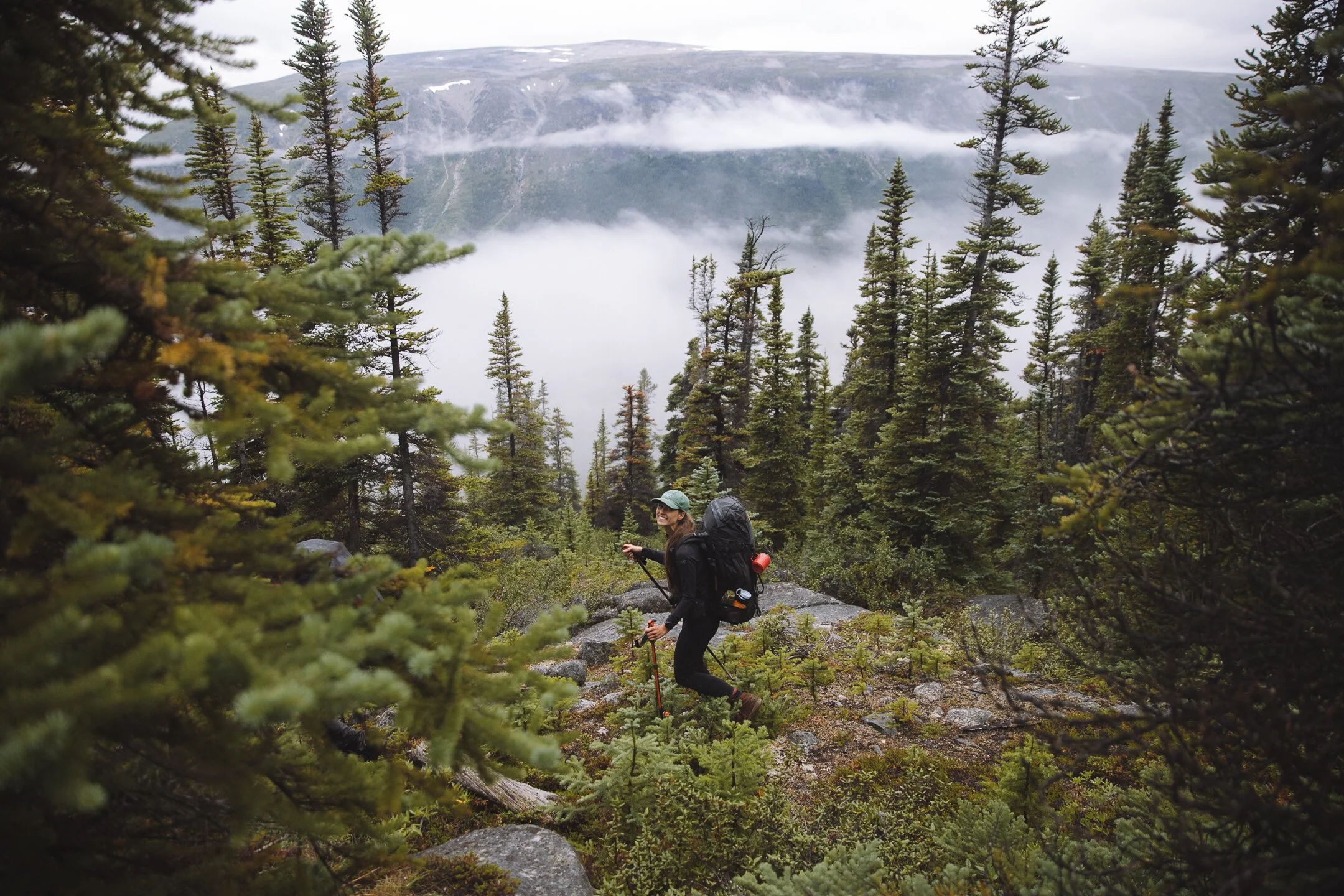
We had an early morning start with a quick gear check (my full gear guide for this backpacking trip is listed below), pack up of our food and any additional supplies from our guide. Our guiding company home dehydrated all of the food for the expedition and we were told in advance that we would need to carry bear bags with our respective food. From here we boarded the helicopter and were transported into the heart of the Yukon Coast Mountains. Dropped off on a small ridge overlooking Rose Lake, we flung our backpacks on and watched as the helicopter flew off into the distance - we were committed. Day one of six. We traversed a ridge-line, dipped low into a valley and then re-gained our elevation where we stopped for our first lunch. We checked over the maps and then slowly made it down to our camp for the first few nights - just in time we set up camp and a storm rolled in. Mike and I spent the majority of the afternoon napping and listening to podcasts in the tent until our guide, Ed, called us for dinner after the storm let up just before 9pm.


Day Three
Distance: 13.04km
Elevation: 771m gain/loss (loop)
This was possibly Mike’s favourite day. We planned for a sunrise hike but the storm came back for some early morning showers and we had a slow start. By mid morning the rain had mostly stopped and we hiked up to Rosette Peak (where apparently there is cell phone service - according to Mike). We made lunch (lasagne - a favourite from the trip) at the summit, took too many photos of the fog rolling in, had a standoff with a herd of caribou and then made our way back to camp. We opted to take the long way. The afternoon was easy and dinner came quickly.


Day Four
Distance: 7.45km
Elevation: 326m gain / 572m loss
This was a camp transfer day and our shortest day. A small gain to a ridge (the same as day one) and then a steep slope down to the lake. Hunting season begins on August 1st and as it was only a few days into the month we were greeted with several groups of hunters - we set up camp next to a local family from Whitehorse and apparently were their good luck charm as they arrived into camp long after we had gone to sleep and we woke up to find that they were successful in their hunt.


Day Five
Distance: 16.25km
Elevation: 771m gain / 643m loss
We woke up early on day five packed up camp early as we knew we had a longer day ahead of us.It rained on and off all day and our lunch was on a small mountain called Bernie where the clouds spent hours dancing around us. We ate our lunch there and, once again, poured over our maps once again trying to formulate a plan. After lunch we veered into uncharted territory. Our guide had never pushed past this mountain so it was a new adventure for us all. After 16km we finally found our consolation lake. It was raining as we set up the tent but we took off our boots and made hot afternoon apple cider and celebrated that we had made it!


Day Six
Distance: 6.86km
Elevation: 627m gain/loss (loop/failed mission)
This was our mission day! We were hoping to make it to Radalet Lake. Unfortunately the weather was not working in our favour and our guide was not comfortable with the terrain necessary to make it to the lake. We hopped up on a ridge that overlooked a vast ice field and made a loop out of our mission down to a small pocket glacier with an ice blue tarn at its base. Some rainy day photos later we carefully made it down a boulder field and returned to our lake. As we carried all of our supplies all day we opted to have lunch on the opposite side of the lake from camp and then traversed the shoreline back to camp just in time for the rain to return. I went to the tent with the intention of taking a nap and instead watched a movie on my phone - Mike and Ed apparently had a riveting conversation about climbing under the tarp. It was a very relaxing afternoon. Our final afternoon.


Day Seven
Distance: 4.30km
Elevation: 69m gain / 703m loss
On our final day in the coast mountains we woke up to (more) light rain and some very low lying fog - we decided to sleep in instead of our planned ascent back to the glacial tarn from day six. After coffee and breakfast we packed up camp and descended to the sandy shore of Primrose Lake where our plane was picking us up at 2pm. As we hiked down, the clouds parted and revealed the sun for the first time since day one (a bad decision to skip the sunscreen this day). We arrived at the lake around 11am and set out our wet gear to dry and began making lunch. All of the sudden out of the forest a man named Andrew emerged - this was startling as we were in the middle of nowhere. He invited us for tea at his cabin and I agreed (and then convinced Ed to come along too) - it turns out our plane out was carrying his bother in. We finished lunch on the beach and then had coffee with Andrew - our plane was about 90 minutes delayed and it was a nice way to spend the afternoon. The plane arrived and carried us up and out for our last look at Primrose Lake and the Coast Mountains.


Day Eight:
Haines junction
Eat
Village Bakery - this is the only place we went(may be the only place in town to go). Coffee is mediocre but the food is amazing.
Sleep
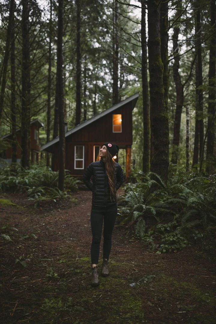
Mount Logan Lodge - book inside the lodge if you want running water (have come back from an adventure day) but they also have a handful of unique stays on site including a tarp tent, a yurt and a renovated school bus. The food at Mount Logan Lodge should not be missed but the times are set with dinner at 7pm and breakfast at 8am so plan to have a non- adventure day when you are there - no sunrises.
Play
Do what we could not and book a Sightseeing tour with Ice-field Discovery - it is 1.5 hours and includes a stop on the glacier. You can also opt to do three nights at their glacier camp. When I return that is what I will be booking.
Backpacking trip: Observation Mountain overlooking the Kaskawulsh Glacier (a 2-3 night backpacking trip).
Day Hike: King’s Throne at Kathleen Lake


Days Nine & ten:
Dawson City
We were told not to waste our time/energy/calories on the cinnamon roll at Braeburn Lodge. So we did not - and I am now passing that wisdom onto you all.
The ultimate Dawson City night out:
5:30pm Cocktail Hour at Bombay Peggy’s
6:30pm Dinner at the Drunken Goat
8:00pm Downtown Hotel - Sourtoe Cocktail (from 9-11pm but get there early to avoid lines - bring $8CDN cash/per toe shot)
(If it is nice out add in a stop at Triple J’s patio for a snack and a drink)
10:00pm or 12:00am Diamond Tooth Gerties for the Can Can Show (the later the better the show gets - this is free but 19+)
(Maybe a stop at the Eldorado for a snack)
Finish the night off at Westminster Tavern and Lounge (aka The Pit aka The Snake Pit)
where to sleep
Aurora Inn - they have a great restaurant for dinner - very European hotel
Bobay Peggy’s - more expensive but nice
Whitehorse Cabins - unique cabins and prospector tents
Downtown Hotel - okay
other useful information
The best coffee in town is at BonTon Butcherie & Charcuterie - the only issue is that they don’t open until 9am. But if they have a ham and cheese breakfast croissant -get that too.
We tried Riverwest and were disappointed. The coffee was expensive and was cold/had been sitting out for hours.


Days Eleven-Thirteen/fourteen
Tombstone Territorial Park
Click Here for my full Tombstone Blog.
final day
Fly Home with Air North (no warm cookies this time but we did get breakfast and still two complimentary checked bags)

Packing Guide:
backpacking in coast mountains
Hiking with a guide is easier in a lot of ways, for this trip it was almost necessary. Without ever having visited the Yukon before and little knowledge not only of the route but the terrain, I would highly recommend hiring a guide for your first backpacking trip. For a trip such as the Tombstones as you may have seen in my guide (click here) a guide is much less necessary. The first backpacking trip I ever went on was with a guided group (my mom, her best friend, my aunt, myself and two guides) - the night before we set out the guides came to our hotel and piece be piece went through our packs. They Vetoed any and all unnecessary items and duplicates. It was a valuable learning lesson for me early on in my hiking career. The guides will answer questions, teach you skills, navigate the trip and, of course, help carry the weight. For this trip our packing list was sent over - I modified their list to be more accurate to my experience - on top of the below packing list I/we were also each responsible for carrying 7kg (15lbs) of dehydrated food, a tent(one tent for 2 people), a provided latrine kit, a large fuel canister and other miscellaneous items. These took up about 25% of my total bag space and the bulk of the weight.
I would recommend always getting a detailed map of the route before you book your trip and have direct contact with your guide. This is not only for safety (you should never head out without your emergency contact knowing your planned whereabouts) but will help you understand the terrain you will be navigating.
Mandatory packing list from our guides:
Socks (one pair for every day plus a backup)
Hiking pants (I also packed shorts and tights)
Warm tights, sweater and sleep socks for warmth at night
For the upper body, you need a combination of layers that you can adapt to all situations.
Short-sleeve hiking t-shirt (I opt for tank tops)
Warm sweater (down or synthetic jacket)
Toothbrush and toothpaste (small), biodegradable soap, baby wipes, small hiking towel
Sunglasses, sunscreen, a sun hat, bug spray with DEET and lip chap
A toque, a pair of gloves and a neck warmer
A pair of sturdy broken in hiking boots (Mike wore trial runners and was perfectly fine)
A pair camp shoes
A pair of sandals for river crossing
A pair of tall gaiters (I did not bring)
Trekking poles ( I don’t use poles but these are mandatory for the communal tarp set up (bring them or else they will supply poles that are very heavy))
Water bottles (2 liters minimum) - I brought one smaller Nalgene for electrolytes and two larger Nalgenes.
A good hiking pack, which provides both comfort and volume. For adults, they recommend a minimum volume of 65L to 70L, depending on your morphology. I brought my tried and true 55L and it was more than enough even with all of my extra layers.
Things I brought that were not included in their mandatory list:
My own tent - I actually brought The North Face Triarch 2 but it is sold out online at the time of writing. The Hubba Hubba is my second favourite 2p tent. If you do not have a tent they will provide you with one but it was much bulkier and heavier than mine and if something were to happen to it I would have been liable so I opted to bring my own.
SteriPen (the guide has a large gravity filter but this was much easier and quicker)
Bear bin (for this I was concerned that I would be stuck carrying a bulky heavy bear bin so I opted to bring my own - I did not end up using it as they use bear bags instead but needed it for the Tombstones regardless)
Garmin Fēnix 6s Pro watch - check out my routes by following me on Strava.
Camp Pillow (always, mandatory)
Coffee and cider - I like an afternoon coffee and an evening cider which was not provided
Electrolyte tablets
Snacks
Battery pack and cables to charge phones and camera gear.
tombstone territorial park
Click Here for my Tombstone Territorial Park blog and packing guide.

Packing guide - everything else
Casual shoes
Patagonia Black Hole - to check at airport with all camping gear inside
Daypack
Extra jackets
Jeans

cost
My trip was booked via Yukon Wild which made a lot of logistical senses - the breakdown cost for this trip for both Mike and I was:
Commercial flights in and out: $560.00 per person
Backpacking trip to Coast Mountains: $2,995.00 per person
Stay at Mount Logan Lodge (2 nights): approximately $350.00 per room dependant on your lodging choice
Stay in Dawson City (2 nights): $375.90 per room
Hotel in Whitehorse (2 nights): $396.90 per room
AirBNB in Whitehorse for final night: $283.01
Tombstone backpacking permits(4 nights)*: $48.00
Transportation(rental car - one week): $915.76
Misc (fuel, food etc)* - I think we spent around $300 in fuel from Whitehorse to Dawson City, Tombstone, Haines Junction and back to Whitehorse. Food in the Yukon is extremely expensive so be prepared.
*not booked by Yukon Wild
note: all prices in CAD
*Please note that some of the links above are affiliate links, and I may earn a small commission on any purchase made - at no additional cost to you. As always, all ideas and opinions expressed in this post are entirely my own. Thank you for your support!


For adventure enthusiasts I can’t imagine a better year-round Canadian destination, with world class surfing (wave dependant), mountain biking, hiking, trail running, sea kayaking… and more passive activities such as whale and bird watching as well as walks with coffee on a seemingly endless maze of trails that are extremely well maintained there isn’t too terribly much that you can not do in Tofino. With just shy of 2,000 permanent residents, Tofino is located on the tip of the Esowista Peninsula at the southern edge of Clayoquot Sound. It is situated in the traditional territory of the Tla-o-qui-aht First Nations.